
Earthquake Damage to Railroads
W. G. Byers Collection: 1964 Alaska
|
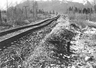
Image-B1440 Irregular settlement of the railroad embankment between the highway grade crossing at mile 62.9 and Bridge 63.0. | |
|
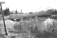
Image-B1441 A 2.6 ft. arch in the deck of Bridge 63.6 over Portage Creek. The deck was only slightly compressed, but was offset horizontally approximately 7 ft. | |
|
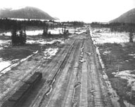
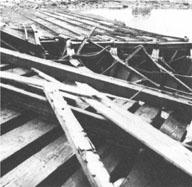
Image-B1442 Tension fractures between tracks on the Whittier branch marshalling yards. The subgrade fill failed by lateral spreading and the ballast failed in tension. | |
|
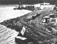
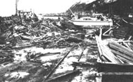
Image-B1443 View of docks, damaged warehouses, single remaining crane, and portion of marshalling yard at Seward after the earthquake and tsunami. | |
|
Image-B1444 Seward marshalling yard after the earthquake and tsunami with damaged freight cars and twisted track. The dock was located at the north end of Resurrection Bay, in the background. | |
|
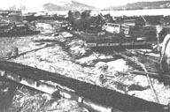
Image-B1445 Burned oil tank cars in the Seward marshalling yard. Damage caused by tsunami. | |
|
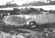
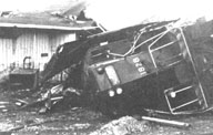
Image-B1446 Locomotive at Seward, overturned by the force of the tsunami. | |
|
Image-B1447 View of railroad tracks about 1 mile north of Seward showing fishing boats and debris on tracks, left there by the tsunami. | |
|
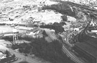
Image-B1448 The Alaska Railroad's equipment-storage building in Anchorage, destroyed by the Government Hill landslide. Government Hill Elementary School stands in the scarp at the top of the slide. | |
|
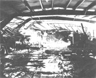
Image-B1449 Interior of the Alaska Railroad's equipment-storage building in Anchorage, destroyed by the Government Hill landslide. The building was demolished. | |
|
Image-B1450 The rail-barge slip at Whittier, used to load railroad cars onto barges, was destroyed by the tsunami. | |
|
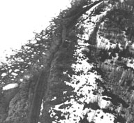
Image-B1451 Kenai Lake slide Mile 21.4, The Alaska Railroad. The state highway from Anchorage to Seward, just out of view at right of photo, sustained no damage in this area. | |
|
Image-B1452 Potter Hill landslide (Rabbit Creek) on the Alaska Railroad between mile 103-104. |
 W. G. Byers Collection
