
Earthquake Damage to Railroads
W. G. Byers Collection: 1964 Alaska
|
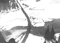
Image-B1422 View south over Bridge 33.0 at the north end of Upper Trail Lake. Compression buckled the bridge deck laterally. Note large ground cracks in the flood plain sediments. | |
|
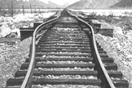
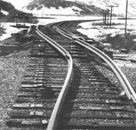
Image-B1423 A lateral buckle in the track at mile 34.3, possibly a result of longitudinal compression of the roadbed. Bridge 34.5 is visible in the background. | |
|
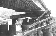
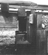
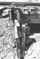
Image-B1424 Caps pulled from bents and sway braces broke on the underside of the jack-knifed deck of Bridge 34.5. | |
|
Image-B1425 Local settling of the railroad embankment between Bridge 34.7 (foreground) and Bridge 34.5 on Hunter Flats. | |
|
Image-B1426 Stringers of extended Bridge 34.7 were pulled 4.5 inches away from the north bulkhead and cantilevered 5.5 inches up off the bulkhead bent. | |
|
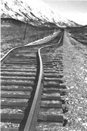
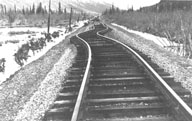
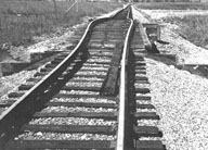
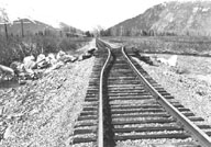
Image-B1427 Lateral kinks in the tracks which may have resulted from longitudinal compression of the embankment. | |
|
Image-B1428 Laterally buckled deck of Bridge 37 on Hunter Flats. The bucking stringers broke free of some bents and pulled others (at apex of bend) laterally through the sediments. | |
|
Image-B1429 View north over Bridge 41.6, where 18 ft. of the approach fill was lowered about 1.5 feet. | |
|
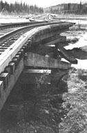
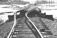
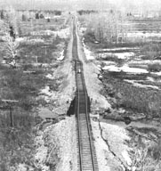
Image-B1430 View north over Bridge 59.6, showing the lowering of the embankment relative to the bridge, compressive bowing of the rails, skewing of the deck, and horizontal displacement of the embankment. | |
|
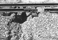
Image-B1431 Stringers of Bridge 59.6 were driven into and through the bulkhead planks. | |
|
Image-B1432 View north over Bridge 59.9 on Skookum Creek flood plain, showing the lowered embankments, buckled rails, and horizontal displacement. This produced a skew of about 3 ft. in the bridge deck. | |
|
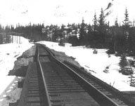
Image-B1433 View north over Bridge 61.3 on the inactive flood plain of Placer River. The bridge was compressed and arched and the embankment settled at the bulkheads. | |
|
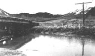
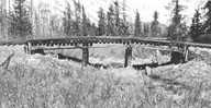
Image-B1434 View north over Bridge 61.5 on the inactive flood plain of Portage Creek. The bridge was compressed and arched, and the rails pulled free of the fish plates. The north approach shifted to the right toward a small slough. | |
|
Image-B1435 View east at bridge 61.5 showing that the embankments were lowered relative to the bridge deck but had risen slightly toward the bridge. | |
|
Image-B1436 Bridge 61.9 from the south. The buckled, compressed rails pulled free of the ties. | |
|
Image-B1437 Approach fills bulldozed against the bulkheads of Bridge 62.1. Central bents were displaced horizontally without rotation, but the bulkhead bent was rotated as its base was carried farther toward the channel than its top. This sort of rotation was very uncommon. | |
|
Image-B1438 Broken and laterally displaced embankment north of Bridge 62.3. | |
|
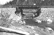
Image-B1439 Spreading of the underlying flood-plain sediments caused the rail to pull apart about 2 ft., also a tension fracture in the roadbed. |
 W. G. Byers Collection
