
Earthquake Damage to Railroads
W. G. Byers Collection: 1964 Alaska
|
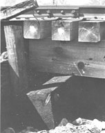
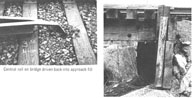
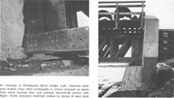
Image-B1401 As a result of compression, the stringers jammed into the bulkhead planking at Bridge 59.6. | |
|
Image-B1402 Laterally buckled and broken stringers of Bridge 37.3 resulting from 7 inches of streambank closure. | |
|
Image-B1403 Bridge 34.5 jackknifed upward due to compression at the bulkheads. Note the mounds of fine-grained sediments ejected with ground water through cracks in the stream floor. | |
|
Image-B1404 Streambank closure of 64 inches drove the deck of Bridge 63.5 through the south bulkhead up onto the top of the embankment. The tops of the pile beneath the deck describe an upward arch, and the deck sagged at the right until it encountered the piles. | |
|
Image-B1405 View to the south of Bridge 63.0. Compression, which deflected the deck 8 ft. to the east in a sharp kink, broke the stringers. A wide tension fracture in the foreground broke the embankment; it shifted to the right at the fracture and skewed the bridge. | |
|
Image-B1406 Bridge 3.0. Left: Central deck on bridge driven back into approach fill. Right: Deck stringers driven 2.5 inches into the bulkhead. Rail pulled free at ties on the embankment. Bulkhead rotated back into the fill and guard timber driven over the top of the bulkhead. | |
|
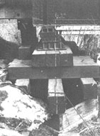
Image-B1407 Piles shifted streamward, rotating the cribbing. Chalk lines at the pier center show the amount of horizontal displacement at the bridge shoes. Wooden stringers were driven several inches into the central steel spans. | |
|
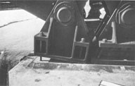
Image-B1409 Fixed end bearing lifted from pier at north end of 6th span of Bridge 14.5. Anchor bolt pulled free of concrete. In adjacent expansion bearing, nested rollers were driven to the extreme position. | |
|
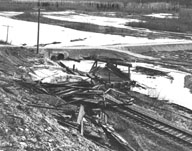
Image-B1410 Damage to 29-Mile River bridge. Left: Concrete abutment broke away after the earthquake. Right: North abutment backwall broken by thrust of steel deck. | |
|
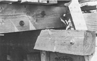
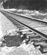
Image-B1411 Unbattered stringers of Bridge 61.9 driven through the south bulkhead planks. | |
|
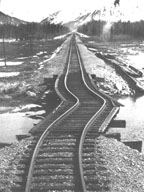
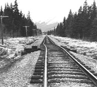
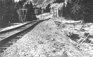
Image-B1412 Subsidence of highway fill at the left displaced the adjacent railroad embankment, and distorted the tracks at a smaller road fill otherwise unaffected by the displacement. | |
|
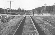
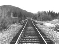
Image-B1413 Looking north toward bridge 62.3, lateral offset of railroad tracks at the site of a filled-over bridge. | |
|
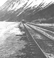
Image-B1414 Waves eroded the railroad embankment lowered by tectonic subsidence along Turnagain Arm. | |
|
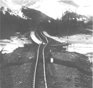
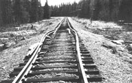
Image-B1415 View north over arched and compressed Bridge 4.8. Sags of about 2 ft. and horizontal displacement of about 1 ft. can be seen in the roadbed to the north. | |
|
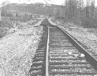
Image-B1416 View over Bridge 15.2 on the inactive floodplain terrace of Snow River. Approximately 950 ft. of the embankment north of the bridge shifted about 1.5 ft. to the west. | |
|
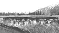
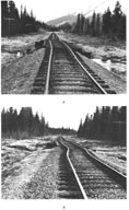
Image-B1417 Bridge 15.6, a 45-ft. wooden trestle on the inactive floodplain terrace of Snow River, showing long, horizontally offset embankments. A, view north; B, view south. | |
|
Image-B1418 Mounds of sand and gravel were ejected with ground water coincident with local dips in the embankment. | |
|
Image-B1419 Rails were distorted when sediments moved toward a small ditch under the embankment, crushing a culvert (barely visible middle right side of photo). | |
|
Image-B1420 The forceful expulsion of ground water excavated a 4 ft. wide by 2 ft. deep cavity beneath the railroad ties. | |
|
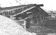
Image-B1421 The concrete deck of a highway overpass at the Snow River delta collapsed onto the railroad. |
 W. G. Byers Collection
