
Jan Kozak Collection: Historical Earthquakes
|
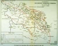
Image-KZ750 Map indicates sites at which Rossi intensities of 3-7 were reported. Epicenter and main fault zones are indicated. (Bohemia (now Czech Republic)) | |
|
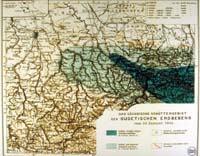
Image-KZ756 Two levels of intensity indicated on the map in shades of blue. Location of the 'great Lausitz dislocation' indicated by red line. (Lausitz, Germany) | |
|
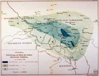
Image-KZ761 Earthquake map. Shows three zones of earthquake intensity based on Rossi scale. (Bohemia (now Czech Republic)) |