|
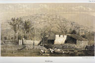
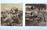
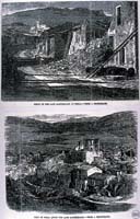
Image-KZ284
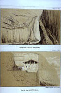
Polla, Italy after the 1857 earthquake. (Lithograph, London, 1862) (Polla, Italy)
|
|
|
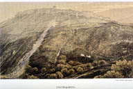
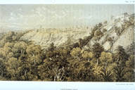
Image-KZ285
Town is seen from a distance, no damage visible. Landslide in foreground. (Castelluccio, Italy)
|
|
|
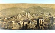
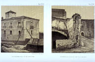
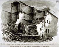
Image-KZ286
Earthquake damage apparent, especially to houses in the foreground. (Padula, Italy)
|
|
|
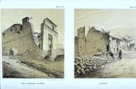
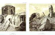
Image-KZ287
Severe damage to the Church of Pertosa (left) and Cathedral of Marsico Nuovo (right). (Pertosa, Italy)
|
|
|
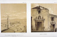
Image-KZ288
Severe damage to the Cathedral of Paterno (left) and town of Auletta (right) (Paterno and Auletta Italy)
|
|
|
Image-KZ289
On left, Church of Santa Domenico at Montemurro ruined. Church at Picerno on right damaged. (Montemurro and Picerno, Italy)
|
|
|
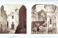
Image-KZ290
Ruined houses in Polla. (Polla, Italy)
|
|
|
Image-KZ291
Left: Strada Rorco in Polla. Right: Cathedral of Tito. (Polla and Tito, Italy)
|
|
|
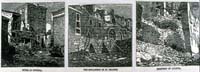
Image-KZ292
Sketch of damaged building. (Auletta, Italy)
|
|
|
Image-KZ293
Structural damage to brick houses. (Auletta, Italy)
|
|
|
Image-KZ294
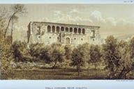
Numerous cracks in Villa Carusso. (Auletta, Italy)
|
|
|
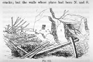
Image-KZ295
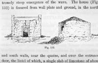
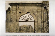
The Porte Cochere on the military road, Villa Carusso, near Auletta. Heavy damage to the columns, numerous cracks. (Auletta, Italy)
|
|
|
Image-KZ296
Pertosa on left, half ruined. On right: the Tenementa della Madonna Campostina with detailed cracks. (Pertosa, Italy)
|
|
|
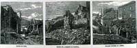
Image-KZ297
Ruined building in Pertosa. (Pertosa, Italy)
|
|
|
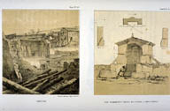
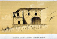
Image-KZ298
Interior court of the Palazzo Palmieri heavily damaged. (Polla, Italy)
|
|
|
Image-KZ299
Left shows fissures on the road near Polla. Town of Polla on the right. (Polla, Italy)
|
|
|
Image-KZ300
Left: Damage to Monastery of St. Claire. Right: Church of the Madonna di Loretto. (Polla, Italy)
|
|
|
Image-KZ301
Houses on the riverbank in Polla. (Polla, Italy)
|
|
|
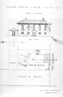
Image-KZ302
Diagram of Palazzo Palmieri showing damage to roof corners, cracks and fissures. (Polla, Italy)
|
|
|
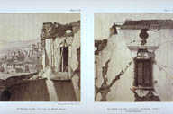
Image-KZ303
Left: interior court of Palazzo Palmieri. Right: interior fa�ade. (Polla, Italy)
|
|
|
Image-KZ304
Two views of structural damage in Atena. (Atena, Italy)
|
|
|
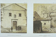
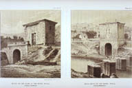
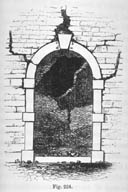
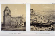
Image-KZ305
Damage to the gate at Padula (Padula, Italy)
|
|
|
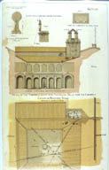
Image-KZ306
Diagram of the Campanile court of the Cistercian Monastery showing damage. (Padula, Italy)
|
|
|
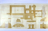
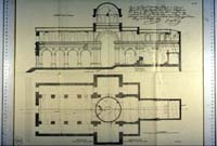
Image-KZ307
Plan of the Cistercian Monastery at Padula showing damage. (Padula, Italy)
|
|
|
Image-KZ308
Churches in the two towns in ruins. (Sarconi and Saponara, Italy)
|
|
|
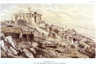
Image-KZ309
Town of Saponara with Castello Cilliberti at the highest point. All structures seriously damaged or ruined. (Saponara, Italy)
|
|
|
Image-KZ310
A mound of rubble where Saponara had been. (Saponara, Italy)
|
|
|
Image-KZ311
Montemurro in ruins (Montemurro, Italy)
|
|
|
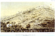
Image-KZ312
Town is too distant to clearly see damage. (Montemurro, Italy)
|
|
|
Image-KZ313
Left: Montemurro: Palace of Don A. Fino. Poles used to brace corner. Right: Barielle: part of a heavy stone wall. (Montemurro, Italy)
|
|
|
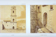
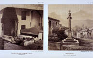
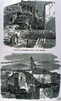
Image-KZ314
Left: Fireplace at the Palazzo Palmieri in Polla. Right: Town square of Montemurro. (Polla and Montemurro, Italy)
|
|
|
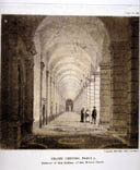
Image-KZ315
Interior of the gallery of the Grand Court. Numerous cracks in corridor ceiling. (Padula, Italy)
|
|
|
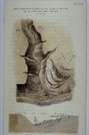
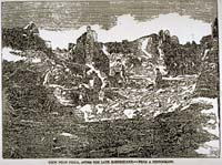
Image-KZ316
Sketch of landslides in the plane of Agri River, caused by earthquake. (Viggiano, Italy)
|
|
|
Image-KZ317
Left: Town of Brienza on left, seriously damaged. Right: Palazzo Romani in Padula: cracks in walls, fallen column. (Brienza and Padula, Italy)
|
|
|
Image-KZ318
Plan of Cathedral at Potenza, mapping the crack pattern. (Potenza, Italy)
|
|
|
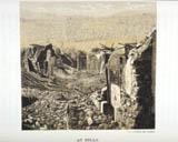
Image-KZ319
Left: Lombardic church at Atella (left) Right: ground fissures at Bella. (Atella and Bella, Italy)
|
|
|
Image-KZ320
On left, massive landslides near waterfall on Monte Vulture. On right, damage to a building in Monticchio. (Newspaper illustration, 1858) (Monticchio, Italy)
|
|
|
Image-KZ321
Damaged and destroyed buildings in Italy. (Newspaper illustration, France, 1858) (Italy)
|
|
|
Image-KZ322
Four views of damage to Pertosa and Polla. (Newspaper illustration, France, 1858) (Pertosa and Polla, Italy)
|
|
|
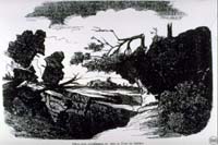
Image-KZ323
Imaginary representation of usual ground effects: cracks in earth, slipping blocks of soil, broken trees, damaged buildings. (Newspaper illustration, France, 1858)
|
|
|
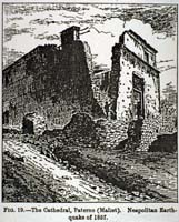
Image-KZ324
Cathedral at Paterno in ruins. (Wood engraving after Mallet, Germany, 1893) (Paterno, Italy)
|
|
|
Image-KZ325
Damaged and ruined buildings in Viguela, Tito, and St. Francis Italy.(Newspaper illustration, New York?, 1858) (Towns in Italy.)
|
|
|
Image-KZ326
Damaged and ruined buildings in Auletta, Atena, Potenza and Padula, Italy. (Newspaper illustrations, New York?, 1858) (Towns in Italy)
|
|
|
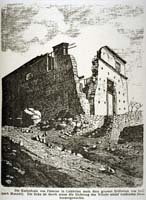
Image-KZ327
Cathedral at Paterno in ruins. (Wood engraving after Mallet, New York, 1886?) (Paterno, Italy)
|
|
|
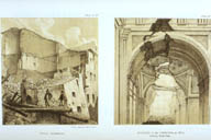
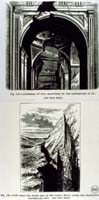
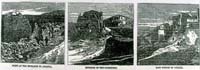
Image-KZ328
Upper view shows Cathedral of Tito, seriously damaged. Lower view is north end of the gorge at Bella, large crevasse in the earth. (Wood engraving, London, 19th c?) (Tito and Bella, Italy)
|
|
|
Image-KZ329
Ruined house in Pola (wood engraving, London, 19th c.?) (Pola, Italy)
|
|
|
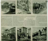
Image-KZ330
Earthquake effects at Potenza with damage to buildings. (Newspaper illustrations) (Potenza, Italy)
|
|
|
Image-KZ331
Geophysical damage near Pola. (Newspaper illustration) (Pola, Italy)
|
|
|
Image-KZ332
Two views of destruction in Pola. (Newspaper illustration, 1858) (Pola, Italy)
|
|
|
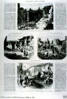
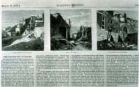
Image-KZ333
Left: ruins at the entrance to Auletta. Center: exterior of the cathedral. Right: eastern portion of Viguella. (Newspaper illustrations, London, 1858) (Auletta and Viguella, Italy)
|
|
|
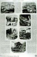
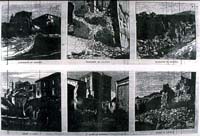
Image-KZ334
Left: ruins of Potenza. Middle: Monastery of St. Francis. Right: Cemetery of Auletta. (Newspaper illustrations) (Potenza and Auletta, Italy)
|
|
|
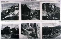
Image-KZ335
Left: ruins of Tito. Middle: ruins of street in Padula, Right: fallen houses at Atena. (Newspaper illustrations) (Tito, Padula and Atena, Italy)
|
|
|
Image-KZ596
Left: east portions of Viguella. Middle: Ruins of Tito. Right: Monastery of St. Francis. (Basilicata, Italy)
|
|
|
Image-KZ597
Auletta, Potenza, and Padula were heavily damaged. (Basilicata region, Italy)
|
|
|
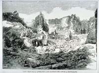
Image-KZ718
View of ruined buildings near Polla. (Newspaper illustration, London, 1858). (Basilicata, Italy)
|
|
|
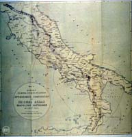
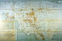
Image-KZ748
Areas in which the earthquake were felt are indicated on the map. (South and Central, Italy)
|
|
|
Image-KZ749
Isoseismal map of central Italy. (Central Italy)
|
|