|
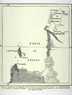
Image-KZ261
Map showing the region of earthquake damage. (Chile, 1876?) (Bahia de Arauco, Chile)
|
|
|
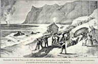
Image-KZ262
"Seaquake" (eruption) and tsunami caused by earthquake. (Lith., Chile and Manchester, 1835) (Bahia Cumberland, Chile)
|
|
|
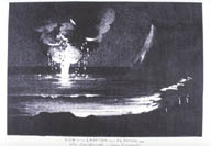
Image-KZ263
View of the eruption from El Pangal, Chile (Lithograph, ca. 1835) (El Pangal, Chile)
|
|
|
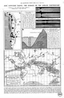
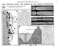
Image-KZ888
"Our unstable earth: the science of the Chilean earthquake." Upper images show location of the earthquakes in Chile and a comparison with the 1906 San Francisco Earthquake. SEE KZ889 for larger view. Lower illustration is "Prof. Milne's earthquake map of the World." SEE KZ887 for detail of map. (Valparaiso, Chile)
|
|
|
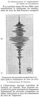
Image-KZ889
"Our unstable earth: the science of the Chilean earthquake." Locations and analyses of the earthquakes in Chile and a comparison with the 1906 San Francisco Earthquake. SEE ALSO KZ888. (Valparaiso, Chile)
|
|
|
Image-KZ897
Seismograph for Valparaiso earthquake. (Valparaiso, Chile)
|
|
|
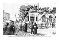
Image-KZ919
"Les ruines de Valparaiso: Aspect de la plaza de la Victoria et du théâtre du męme nom aprčs les derničres secousses. Nous avons dčjŕ publié, la semaine derničre, une premičre photographie montront la façade du théâtre de la Victoria. On remarquera qu'entre les deux photographie, ŕ la suite de nouvelles secousses, l' écroulement du théâtre est devenu plus complet encore." (Valparaiso, Chile)
|
|
|
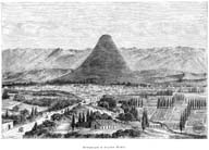
Image-KZ921
The city of Arequipa before the earthquake. (Arequipa, Peru)
|
|