Jan Kozak Collection: Historical Earthquakes

|
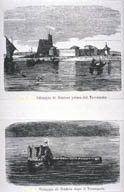
Image-KZ248 Top view shows settlement prior to earthquake. Bottom view shows after, the village disappeared under the surface of a newly created lake. Only the damaged fortress tower remains above water level. (Steel engraving, Italy, 1869?) (Sindri, Rajasthan, India) | |

|
Image-KZ249 Top view shows fortress in 1808 (11 years before the earthquake). Bottom shows ruin of fortress in 1869 (50 years after earthquake). (Engraving, France, 1869) (Sindri, Rajasthan, India) | |

|
Image-KZ745 Map of India showing the general and local observed directions of earthquake ground motion. (India) |
