|
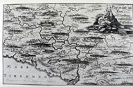
Image-KZ56
Map of region north of Rome damaged by a series of earthquakes in Jan./Feb., 1703. Towns damaged by earthquake are named. Zones of greatest damage can be identified. (Copper engraving, Germany, 1703.) (Lazio region (Abruzzi))
|
|
|
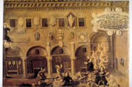
Image-KZ57
Street scene in front of Palazzo Comunale in Tolentino: General panic and confusion but no visible damage. (Painting, after 1703) (Tolentino (Marche) Italy)
|
|
|
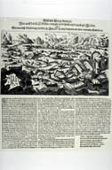
Image-KZ58
An image of the eruption of Mount Etna (1669) and the Val di Noto earthquake (1693) was adapted for this depiction of the 1703 earthquake in central Italy (Norcia-Aquila). This was common practice in Central and Northern Europe when depicting distant events where no authentic image was available. (Copper engraving, Germany, 1703?) (Italy)
|
|
|
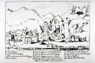
Image-KZ59
There was a series of earthquakes in central Italy in Jan/Feb., 1703. This is a sketch of damaged locales, with captions. Shows surface fractures and subsidence(?) (Drawing, Italy, 1703?) (Norcia-Aquila region, Italy)
|
|
|
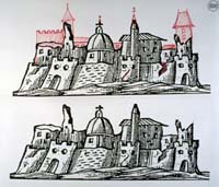
Image-KZ820
Illustration of medieval fortified town believed to be L'Aquila. Damaged by a series of earthquakes which occurred from January 14 to February 8, 1703 (according to the report). The red area shows what the town is supposed to have looked like before the damage.
|
|