|
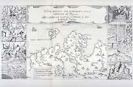
Image-KZ35
Map of Apulia (Puglia) Province. With 8 added images of the effects of the San Severo earthquake. (Copper engraving, copied from KZ37, 1627)
|
|
|
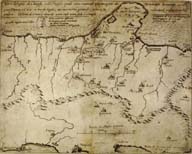
Image-KZ36
Map of Apulia showing damaged towns, including San Severo. Four degrees of damage are shown in the legend and applied to the damaged towns so that isoseismal lines could be drawn. One of the first maps showing degrees of damage. (Copper engraving, Rome, 1627) (Apulia (Puglia) Province)
|
|
|
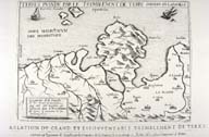
Image-KZ37
Map of epicentral area, damage described in text but not shown on map. (Copper engraving, Lyons, 1627) (Apulia (Puglia), Italy)
|
|
|
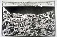
Image-KZ38
'Report on the large and terrible earthquake which took place in the Kingdom of Naples in the Province of Apulia on Friday, July 30, 1627. From which it is to be learned with shock of the devastation of several cities, market towns and boroughs and the demise of more than 17,000 persons.' This is the German-language version of the original broadside by Giovanni de Poardi of Bologna, printed in Rome in 1627. (Woodcut, Augsburg, 1627) (San Severo, Italy)
|
|
|
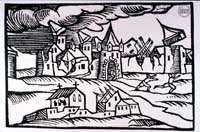
Image-KZ865
Naif woodcut depicting generic earthquake damage to a town in Puglia (Apulia), possibly San Severo.
|
|