
The Earthquake Engineering Online Archive NISEE e-Library
 Identifier: Text-201303201
Title: Field trip : San Francisco Peninsula
Creator(s): Bonilla, Manuel G.; Schlocker, Julius
Identifier: Text-S19285
Title: Surface faulting near Livermore, California, associated with the January 1980 earthquakes
Creator(s): Bonilla, Manuel G.; Lienkaemper, James J.; Tinsley, John C.
Identifier: Text-S21323
Title: Faulting related to the 1915 earthquakes in Pleasant Valley, Nevada
Creator(s): Wallace, R. E.; Bonilla, Manuel G.
Identifier: Text-S21648
Title: Effects of the earthquake of March 27, 1964, on the Alaska Railroad
Creator(s): McCulloch, David S.; Bonilla, Manuel G.
Identifier: Text-S27844
Title: Historic surface faulting in continental United States and adjacent parts of Mexico; a factor in nuclear facility siting and design
Creator(s): Bonilla, Manuel G.
Identifier: Text-S27845
Title: Interim report on worldwide historic surface faulting
Creator(s): Bonilla, Manuel G.; Buchanan, Jane M.
Identifier: Text-S27913
Title: Evaluation of potential surface faulting and other tectonic deformation
Creator(s): Bonilla, Manuel G.
Identifier: Text-S28148
Title: Geology of the San Francisco North quadrangle, California
Creator(s): Schlocker, Julius; Bonilla, Manuel G.; Radbruch, Hall D.
Identifier: Text-S28744
Title: Minimum earthquake magnitude associated with coseismic surface faulting
Creator(s): Bonilla, Manuel G.
Identifier: Text-S28911
Title: Landslide susceptibility in San Mateo County, California
Creator(s): Brabb, Earl E.; Pampeyan, Earl H.; Bonilla, Manuel G.
Identifier: Text-S29793
Title: Approximate trace of the main surface rupture in the San Andreas Fault zone between Pacifica and the vicinity of Saratoga, California : formed during the earthquake of April 18, 1906
Creator(s): Schlocker, Julius; Pampeyan, Earl H.; Bonilla, Manuel G.
Identifier: Text-S29969
Title: Preliminary geologic map of the San Francisco South quadrangle and part of the Hunters Point quadrangle, California
Creator(s): Bonilla, Manuel G.
Identifier: Text-S29971
Title: Bedrock-surface map of San Francisco North quadrangle, California. Bedrock-surface map of San Francisco South quadrangle, California
Creator(s): Schlocker, Julius; Bonilla, Manuel G.
Identifier: Text-S29983
Title: Landslide susceptibility in San Mateo County, California
Creator(s): Brabb, Earl E.; Pampeyan, Earl H.; Bonilla, Manuel G.
Identifier: Text-S33584
Title: Guide to San Francisco peninsula
Creator(s): Bonilla, Manuel G.; Schlocker, Julius
Identifier: Text-S33605
Title: Geologic and seismic investigations of a proposed nuclear power plant site on Bodega Head, Sonoma County, California
Creator(s): Schlocker, Julius; Bonilla, Manuel G.; Clebsch, Alfred
Identifier: Text-S33606
Title: Engineering geology of the proposed nuclear power plant site on Bodega Head, Sonoma County, California
Creator(s): Schlocker, Julius; Bonilla, Manuel G.
Identifier: Text-S39110
Title: Factors affecting the recognition of faults exposed in exploratory trenches
Creator(s): Bonilla, Manuel G.; Lienkaemper, James J.
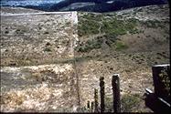 Identifier: Image-S1277
Title: The 1906 faulting offset this fence
Creator(s): Bonilla, Manuel G.
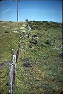 Identifier: Image-S1278
Title: The 1906 faulting offset this fence
Creator(s): Bonilla, Manuel G.
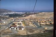 Identifier: Image-S1279
Title: San Andreas Fault, Daly City
Creator(s): Bonilla, Manuel G.